According to the regional development, Estonia can be divided into three parts
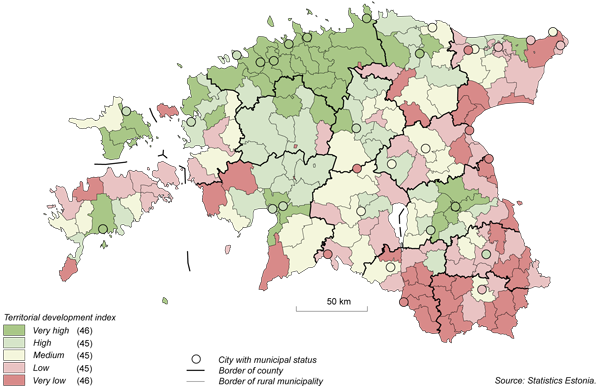
The territorial development index of local government unit shows that the most problematic regions of Estonia are the areas in the proximity of Lake Peipus and Southeastern Estonia. On the map of Estonia, we can draw an imaginary axis that starts from Vaivara rural municipality located in Ida-Viru county, runs along the coast of Lake Peipus and the border of Latvia, and ends at Häädemeeste. Tallinn together with Harju county can clearly be distinguished from among the most successful regions. For example, 18 rural municipalities and cities of Harju county ranked among the first 25 local government units. Tartu city and Pärnu city together with the rural municipalities surrounding these cities can also be regarded successful. The third area that runs diagonally across Estonia from the Gulf of Narva to the Gulf of Riga is positioned in between the problematic region and the successful one.
The indices published earlier have also provided a similar picture of the regional development of Estonia. For example, Statistics Estonia’s viability index of local government units and the capacity index of local government units compiled by Geomedia OÜ. Local government units position differently in case of different indices, but the situation of the regional development of Estonia remains relatively similar.
The territorial development index of local government unit consists of four components — population change, dependency ratio, personal income tax per inhabitant and proportion of registered unemployed persons.
Territorial development index of local government unit, 2008
More detailed analysis has been presented today, on 26 November, in the publication “Linnad ja vallad arvudes. 2009. Cities and Rural Municipalities in Figures“(/uudised/31364).